Landscaping and open spaces
Prioritising green open space to create vibrant and well connected community areas
As part of the proposals, Bloor Homes is proposing to retain almost 70 hectares (equivalent to 130 football pitches) will be retained as areas of public open space that will be accessible to all, designed to foster community activities and recreational opportunities, demonstrating Bloor Homes’ commitment to prioritising the protection and enhancement of the existing landscape.
The development will enhance key natural features, including the historic field boundary, new trees, hedgerows, and a reinstated pond, creating habitats for wildlife and enjoyable green spaces. Gentler riverbanks and native planting along the Great Ouse and Gallow Brook will support diverse wildlife.
A 2.5km walking route and areas like a wildlife pond and “Conservation Island” will provide accessible green space, while bat and bird boxes, insect hotels, hedgehog-friendly fencing, and dog-friendly areas will help residents connect with nature every day.
As a result of the above measures, the proposed development will achieve a 10% biodiversity net gain.

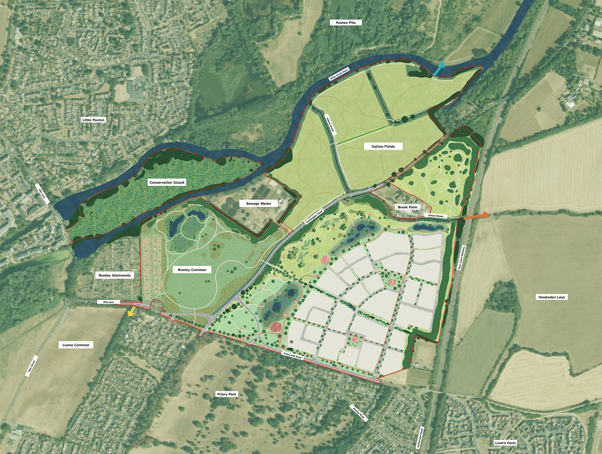
 Application Boundary (87.20ha)
 Developable blocks
 Amenity grass
 Meadow grass
 Arable land with mown paths
 Understorey scrub planting
 Structural planting and woodland
 Conservation island
 Common land
 Proposed areas for Play
 Allotments
 Attenuation basins
 Nature ponds
 Shared cycle and footpath
 Footpath
 Permissive footpath under railway line to connect to Hawkesen Leys
 Potential future bridge connection over to Ouse Valley Long Distance Walking route and Paxton Pits
 New crossing point over Mill Lane to connect commons
 Proposed community hub
Green infrastructure masterplan
Six core component areas
The Green Infrastructure masterplan is comprised of six core component areas, which employ varying characteristics and functions, along with additional landscaping features embedded within the residential area, delivering on the objectives of the Place Strategy and vision for the scheme.
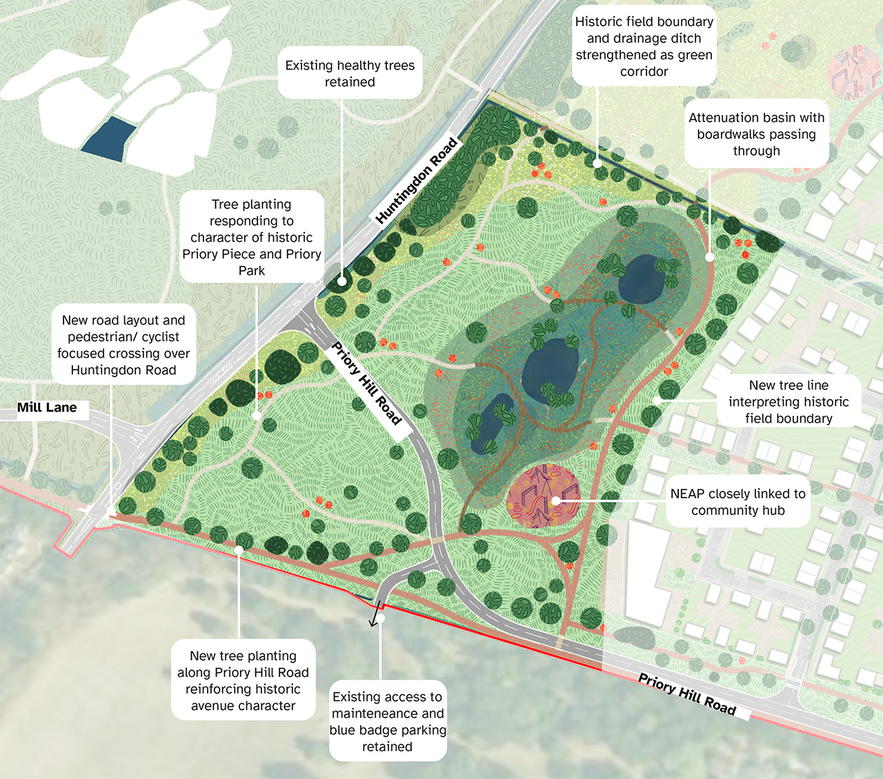
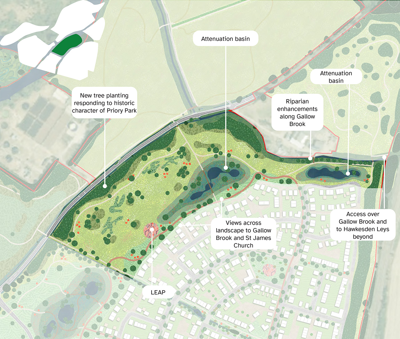
1. Priory Piece Parkland
Formal parkland restoring the historic extents of Priory Park
- Extension of Priory Park, as Priory Piece will restore the historic parkland and connect directly to Priory Park with new walking and cycling routes.
- Amenity green space will largely include grassland, with an attenuation basin. The community hub is also located close to this area, with an area of outdoor terracing, meaning the Neighbourhood Area of Equipped Play (NEAP) is located in this section.
- Paths and boardwalks will wind through the landscape, with sunny west-facing slopes offering views over the valley and river.
- Green Character with new woodland, hedgerows, and specimen trees will reflect the character of Priory Park and enhance biodiversity.
- Better Connections as a re-routed road will run through the area, while the former road becomes a pedestrian and cycle link between Mill Road and Priory Hill Road.
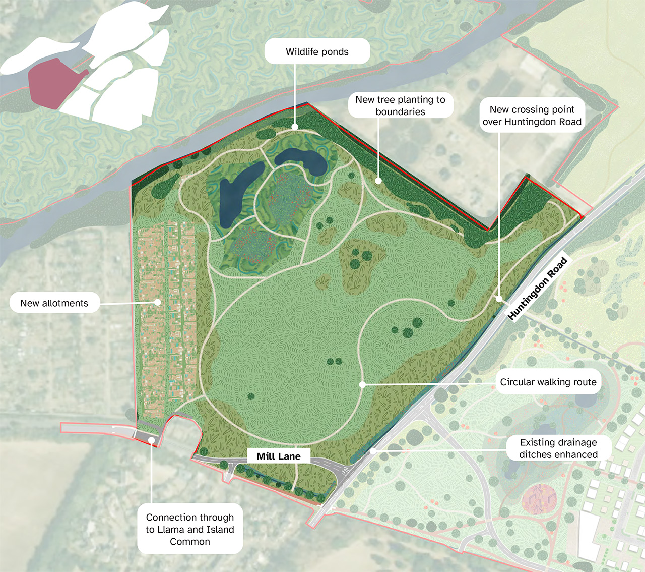
2. Rowley Common
A versatile common linked to the River Great Ouse
- Rowley Common encompasses a variety of uses and habitats, and acts as an extension to existing common land along the river corridor.
- Potential to complement the existing characteristics of Island Common through the provision of multifunctional natural and amenity open space, acting as an alternative accessible green space buffer to Paxton Pits Nature Reserve, maintaining the separate identity of St Neots and Little Paxton, with an 2km footpath network in a figure of 8 walking loop.
- Provision of safeguarded wildlife areas along the river corridor, with limited access, drawing from the floodplain meadow character of the Great Ouse valley.
- Areas of open grassland and scrubland, retaining expansive views across common land to adjacent open space and Paxton Hill.
- Potential an extension to Rowley Allotments, with access maintained from Mill Lane.
- A new, safe crossing across Mill Lane connecting the green spaces in Llama and Island Common to the development.
3. Priory Meadow
Transitional landscape between town and country
- Gradual transition between formal parkland it will act as a bridge between the more formal Priory Piece and the natural meadows to the north, with a mix of formal and mown seasonal pathways. New crossing points over Huntingdon Road will connect to Gallow Fields, the Common Land, and a proposed bridge to Paxton Pits.
- Substantial landscape buffer along Gallow Brook, with opportunities to widen channel, soften banks and introduce new in-stream habitats for wildlife.
- Potential for access routes as the existing track under the railway line could become a permissive footpath, linking Hawkesden Leys and the rights of way network east of the railway with new green spaces to the west via a rural bridge over Gallow Brook.
- Stormwater flows and filters through a system of features including two new basins which will provide amenity space as well as manage surface water. Stormwater will be collected through SuDS features across the development and stored before filtering gradually into Gallow Brook.
- Play areas for residents as this area will include a Locally Equipped Area of Play (LEAP), several Local Areas of Play (LAPs), and natural play features, with potential for water-based play integrated into the landscape.
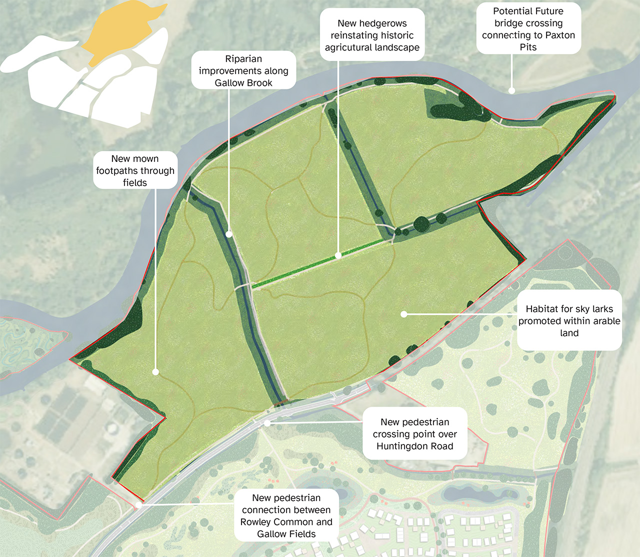
4. Gallow Fields
Accessible countryside close to home
- Arable land to be retained that, in combination with Rowley Common, acts as a landscape buffer between the development and Little Paxton and Paxton Pits.
- Wildlife enhancement, as while remaining arable, field, brook, and river margins will be improved to create stronger habitats for nature.
- New footpaths and mown routes will open up access to the countryside and river corridor.
- Potential river crossing to Paxton Pits, with space being safeguarded for a potential bridge, creating a direct link to Paxton Pits and the Great Ouse walking trail.
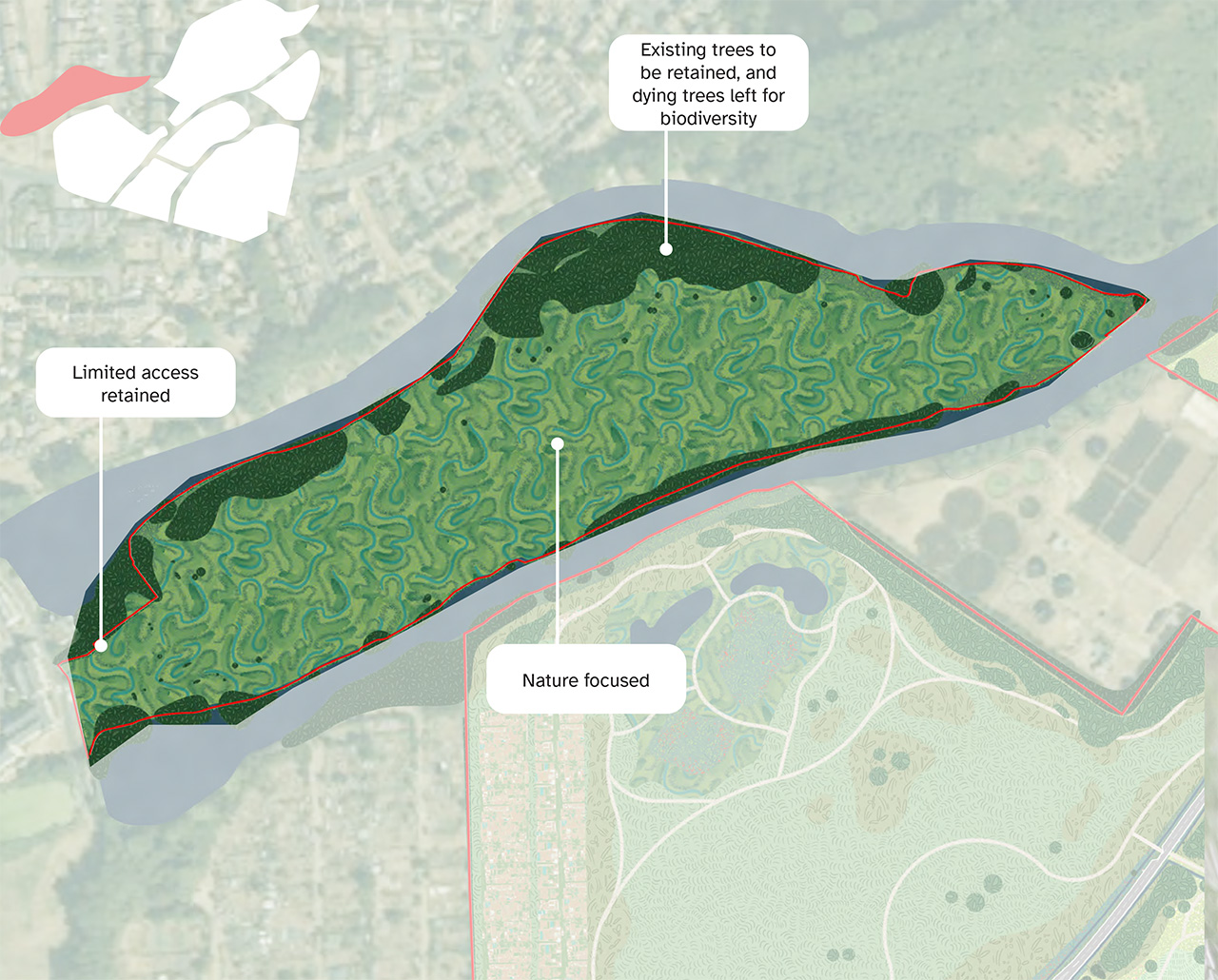
5. Conservation Island
A refuge for wildlife
- An ecologically rich environment, which is bound by two channels of the River Great Ouse and to the east of Mill Lane, Conservation Island acts as a stepping stone between SSSI’s along the river corridor.
- Acts as a natural buffer between St Neots and Little Paxton, maintaining separate identities of the two settlements.
- Access to be restricted and habitats managed (potentially through conservation grazing) to maintain the biodiversity value of the landholding.
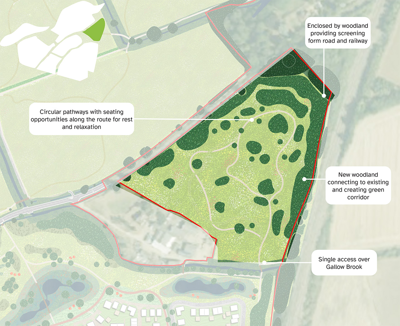
6. Brook Meadow
A place for contemplation and reflection
- Brook Meadow lies north of Brook Farm and Gallow Brook, east of Huntingdon Road, and west of the railway, connecting to the wider site via a new rural bridge over Gallow Brook, linking into Hawkesden Leys and the public rights of way network.
- The land could in time serve as a woodland cemetery with access from Huntingdon Road, if a need arises.
- The meadow will extend the surrounding grassland character, framed by woodland and crossed by smaller formal footpaths.
- A tranquil and reflective community space, with seating areas and features to support wildlife and moments of nature engagement.
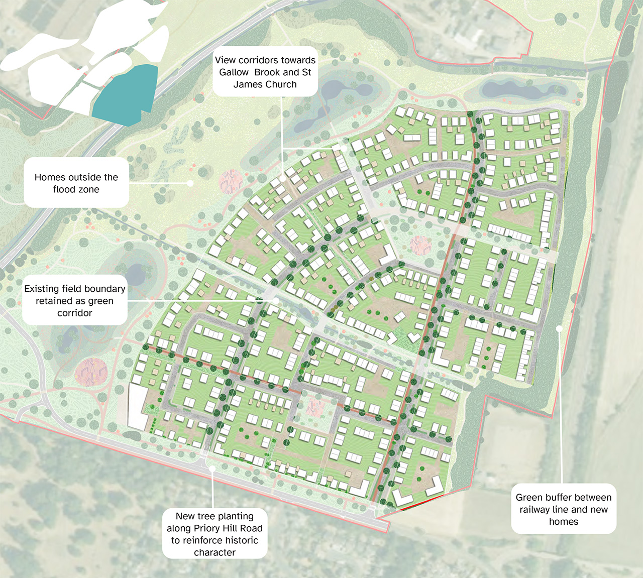
Priory Hill Neighbourhood
Living with wildlife
- Development located on higher ground out of the floodplain, with the railway to the east, Gallow Brook to the north, and Priory Hill Road to the south.
- Provision of a wooded and grassland buffer along the eastern edge will screen views from the east, form a wooded backdrop in views from the west, helping integrate the development with the wider landscape, adding amenity and ecological value.
- Residential area to be integrated with Green Infrastructure as the neighbourhood will include tree-lined streets, green spaces, parklets, and verges with SuDS features such as swales and rain gardens, enhancing biodiversity and drainage.
- Existing green corridors will be retained, and measures such as bird and bat boxes, insect hotels, and hedgehog highways will support wildlife across the development.